
Although considered to be a less technically complex activity by most surveyors , cadastre and related projects are a significant part of the volume of surveying output, both in Bulgaria and globally.
Nor could it be otherwise, given that these activities are linked to the ownership of territories, which are in large part not just a geographical concept but a means of producing added value for their owners.
From the point of view of the state structures, on these territories the cadastre and related activities provide information for the tax system and respectively the collection of property taxes.
Since our foundation, we at GeoHead have been paying attention to land ownership projects.
Prior to 1990, most of the longer tenured professionals currently working at GeoHead were involved in the creation of Cadastral Plans for settlements to the then existing standards, including the ISEC (Uniform Cadastre Information System) the original version of the current Cadastral Map and Registers.
After 1990 we participated in the restitution of agricultural land with projects on 100,000 acres .
Since 2000, when the first loan was concluded with a world bank for the creation of a cadastral map and registers according to the European model, we have been carrying out activities on the cadastre and related master plans, master plans, etc.
Our main activity related to KK and KR is the creation of GMMP and RGO for territories throughout the country, as well as fully created cadastral maps of settlements related to the activities of our regional offices in Pleven , Montana, St. Zagora and Skopje.
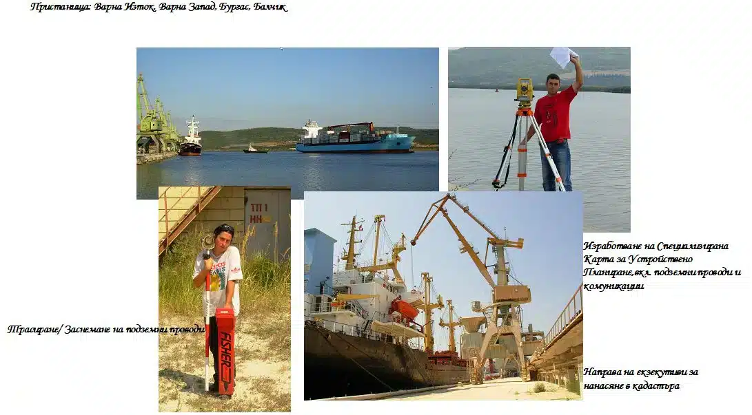
We also draw attention to the creation of SCUPs (specialised spatial planning maps). The company is significantly more active in this area. We have completed projects for areas mainly related to port infrastructure at most major public transport ports of national importance , for over 200,000 acres.
Everything said so far should illustrate the fact that we have considerable experience in the field of Cadastre and related activities, which makes any project assigned to us in this direction possible and cost-effective.
SOME OF THE PROJECTS IMPLEMENTED IN BULGARIA
Preparation of cadastral plans Varshets municipality – 8 settlements
Preparation of cadastral plans Berkovitsa municipality – 6 settlements
Preparation of cadastral plans Montana municipality-19 settlements
Underground cadastre of the areas around the BAS nuclear reactor
Cadastral and Information System of Montana Region, Bulgaria
Land reform in Bulgaria over 100 000 acres in Berkovitsa municipality
Land reform in Bulgaria – Measurement and processing of support networks
Production of a digital cadastre of Knezha
Preparation of a digital cadastre of the land managed by NEK-EAD – Rodopi dam area
Digital model of protected areas Rila, Cental Balkan
Establishment of a local geodetic network SR Balchik
Specialized maps for port planning Varna-East
Specialized maps for port planning Varna-East
Specialized maps for port spatial planning.
Specialized map for spatial planning of the port of Balchik
Specialized maps for port spatial planning Ruse-East
Specialized maps for port spatial planning Ruse-West
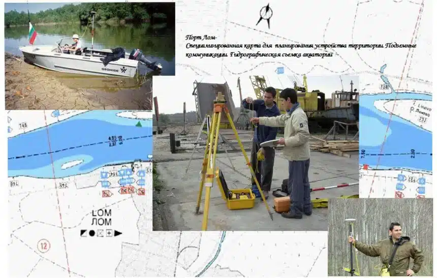
Specialized map for the Port of Lom spatial planning
Specialized map for spatial planning of Merchaevo district Sofia Municipality
GMMP Municipality of Sliven
GMMP Vitosha Municipality
GMMP Novi Iskar Municipality
GMMP Belitsa Municipality
GMMP Judicial District Balchik
KKR Ruse port Ruse centre
Lilakovitsa tailings
Full survey of the dam and the area from the dry side to 1km.
Development of a project, including methodology and technology for monitoring the deformation of the dam.
Building the elements of the monitoring system.
Measurement and processing of results.
Creation of software for analysis and comparison of measurement results with accumulation.
KKR, Polski Trambesh
CCR Chiprovtsi
Damyanovo village
Geodetic activities related to commissioning and obtaining certificates under Article 52 of the Land Registration Act”, on objects:
-Hydrovozel “Tsankov Kamak”
-Relocation of existing road III – 868 Devin – Mihalkovo
Monitoring of the hydraulic engineering facilities at the Varna – East port terminal, part of the Varna port of national importance and the Lom port terminal, part of the Lom port for public transport of national importance
CREATION OF SPECIALIZED MAPS AND REGISTERS OF SEA BEACHES”, Lot No. 4 – Creation of specialized map and registers for sea beaches “Romance” beach – Kamchia CC in the land of the village of. Bliznatsi, Avren Municipality, Varna Region, sea beaches in the land of Kam Kamchatka. Byala, Byala municipality, Varna region,
gr. Obzor, s. Emona, gr. St. Vlas, St. Nessebar and. Ravda, Nessebar Municipality, Burgas Region
Measurement of the deformation of the wall of the “Dusantsi” dam
Preparation of plans of the newly formed properties of agricultural land under §4 of the Law on Agricultural Land on the territory of the Municipality of Troyan, Lovech region for the town of Troyan. Troyan, s. Balabansko, s. Balkanets, village of. Beli Osam, s. Belish, s. Borima, s. Vrabevo, s. Golyama Zhelyazna, s. Gorno Trape, s. Gumoshtnik, s. Dobrodan, s. Kaleitsa, s. Lomets, s. Patreshko, s. Cherni Osam, s. Chiflik, s. Shipkovo
Design and construction of KIS and ‘zero’ point measurement for the purpose of establishing deformations of the embankment by geodetic methods for the object “Correction of the Lesnovska River from km 13+108-km. 12+668- restoration of the right embankment, Chelopechene district, Sofia


